Ontario’s Great Lakes Strategy: Second progress report
Read about the actions we’ve taken under the Great Lakes Strategy to improve the environmental, social and economic health and wellbeing of the Great Lakes.
Message from the minister
As someone who lives along Lake Ontario, I am very proud to call the Great Lakes region home. There is an incredible natural legacy in these lakes and rivers, and they are central to the quality of life and strong industry that we enjoy in our province. The Great Lakes support almost 40% of Canada’s economic activity and are a vital source of safe drinking water for most of our province. They also hold great historic and cultural significance. First Nations peoples have maintained a strong spiritual and cultural relationship with the Great Lakes and the Basin is where Métis identity emerged in Ontario.
Ontario continues to take action to protect, conserve and restore the Great Lakes, and one of the ways we are doing this is through Ontario’s Great Lakes Strategy. The strategy was introduced in 2012 and includes initiatives from 16 provincial ministries to further the environmental, social and economic health and well-being of the Basin.
This is the second progress report on the actions we’ve taken under the strategy, and it shows the considerable progress we are making to safeguard the Great Lakes.
In the pages that follow, you will read about how Ontario is investing in local actions and supporting partnerships to restore and protect wetlands and wildlife. You will also gain a better understanding of the economic importance of agriculture in the Great Lakes Basin, and the agri-environmental stewardship programming delivered by Ontario that focuses on positive outcomes for soil health, water quality and climate change.
This report also details how Ontario’s investments in stormwater and wastewater management will make a difference in improving water quality and outlines how we have supported municipalities and communities around the Basin to prepare for, and adapt to, climate change.
Ontario’s Great Lakes Strategy is a living document, and we will continue to update it to meet the latest challenges. A review of the strategy is underway, and we will engage the Great Lakes community and partners in this process to ensure the updated strategy is reflective of the needs of the Basin today and for years to come.
While much work remains to be done, this report shows that our efforts are making a difference. We will continue working together with all the Great Lakes community partners and the public to protect the health of the Great Lakes so they can be enjoyed today and for generations to come.
The Honourable David Piccini
Minister of the Environment, Conservation and Parks
Introduction
Ontario’s Great Lakes Strategy (also known as the strategy
) was introduced in 2012 to ensure the Great Lakes continue to provide clean water to drink and where it is safe to go swimming and fishing. The strategy identified six goals to protect and restore the health of the Great Lakes and St. Lawrence River Basin:
- Engaging and empowering communities
- Protecting water for human and ecological health
- Improving wetlands, beaches and coastal areas
- Protecting habitats and species
- Enhancing understanding and adaptation
- Ensuring environmentally sustainable economic opportunities and innovation
The Great Lakes Protection Act, 2015, requires that the Minister of the Environment, Conservation and Parks maintains the strategy and report on, among other things, actions that have been taken to address the priorities identified in the strategy. In 2016, Ontario reported on the accomplishments achieved in the first three years of implementing the strategy in its first progress report. The second progress report is intended to be read in conjunction with the first report as it highlights achievements made since that first report to early 2022, and encompasses actions and efforts across the 16 Great Lakes ministries:
- Agriculture, Food and Rural Affairs
- Economic Development, Job Creation and Trade
- Education
- Energy
- Environment, Conservation and Parks
- Finance
- Municipal Affairs and Housing
- Indigenous Affairs
- Health
- Infrastructure
- Intergovernmental Affairs
- Mines
- Natural Resources and Forestry
- Northern Development
- Tourism, Culture and Sport
- Transportation
Goal 1: Engaging and empowering communities
The Great Lakes, St. Lawrence River and their surrounding lands and waterways give us a high quality of life, and their importance to the people of Ontario is reflected in the number of individuals, communities, and organizations that contribute to their protection and restoration. First Nations peoples have lived and thrived in the Basin for millennia, relying on the lakes as a source of food and water, and building cultural and spiritual relationships with the land and water. The Anishinaabe people, many who continue to live in the Basin today, identified the Great Lakes as Nayaano-nibiimang Gichigamiin, which means the five freshwater seas
in the Anishinaabemowin language. The Mohawk people have long-standing ties to the St. Lawrence River Valley, and the St. Lawrence River is also known as Kaniatarowanenneh, which is Mohawk for the ‘big waterway,’ or River of the Iroquois.
The purpose of engaging and empowering communities is to create opportunities for individuals and communities to become more involved in the protection and restoration of the ecological health of the Great Lakes Basin. Actions in the strategy include supporting collaboration and partnerships with governments and with First Nations and Métis communities, building awareness, and supporting community action.
Collaboration and partnerships
Supporting and engaging in collaboration and partnerships with the broad Great Lakes community to generate awareness and local action on the Great Lakes is a key component of the Ontario’s Great Lakes Strategy.
Ontario continues to collaborate with Canada and other Great Lakes jurisdictions by being an active participant, advisor and/or member on numerous commissions, councils and committees, such as the:
- Great Lakes Executive Committee under the Canada-U.S. Great Lakes Water Quality Agreement
- The Executive Committee under the Canada-Ontario Agreement on Great Lakes Water Quality and Ecosystem Health
- Great Lakes Commission
- Great Lakes Fishery Commission
- Great Lakes-St. Lawrence Governors and Premiers
- Regional Body of the Great Lakes-St. Lawrence River Basin Sustainable Water Resources Agreement
- International Joint Commission committees, boards and tasks teams
In addition, Ontario continues to collaborate with various agencies and other partners, such as academia, to advance our knowledge and scientific understanding through identification of science priorities, such as participating in the State of the Lake Conferences to report on findings and identify science priorities and future work, participating in the Great Lakes Mapping Coalition, providing data and information to support assessments, priority setting, and day to day collaborations on Great Lakes projects.
Collaboration with First Nations and Métis partners to protect, restore and conserve the Great Lakes Basin is a particularly important component of the strategy. The Ministry of the Environment, Conservation and Parks has worked with First Nations communities to support a range of Great Lakes projects and initiatives, including community-based monitoring, habitat and species restoration efforts, shoreline cleanups, gatherings with First Nations youth and Elders and supporting Traditional Ecological Knowledge. This has included work led by M’Chigeeng First Nation, Chippewas of the Thames First Nation, Mohawk Council of Akwesasne, Walpole Island First Nation and Magnetawan First Nation, who each hosted Traditional Ecological Knowledge workshops to support the development of Indigenous Knowledge databases. Other community-led projects, such as work led by Red Rock Indian Band, have helped to map valued ecosystem components and support watershed management and climate change adaptation planning. Ontario’s other Great Lakes ministries also continue to work with First Nations and Métis and play an integral role in collaboratively advancing Great Lakes protection and restoration efforts.
Other examples of collaborative efforts among the Great Lakes community to address priority issues in the Great Lakes Basin include:
Groundwater chemistry mapping on Manitoulin Island
In 2017, the Ontario Geological Survey collaborated with local Indigenous communities to carry out a groundwater chemistry mapping campaign on Manitoulin Island, resulting in mutually beneficial information and resource sharing. Community members shared knowledge of groundwater spring locations to inform sampling locations, and results were provided to homeowners and community members. The project helped the province characterize groundwater geochemistry of the major rock and overburden units in Ontario, and provided water quality information to community members.
4R Nutrient Stewardship Program
Following the initiation of the partnership in 2015, Fertilizer Canada partnered with OMAFRA, the Ontario Agri Business Association, Grain Farmers of Ontario, Ontario Federation of Agriculture, and Christian Farmers Federation of Ontario to implement the 4R Nutrient Stewardship (Right Source @ Right Rate, Right Time, Right Place®) program in Ontario. In 2018, the voluntary 4R Certification program was launched and works to audit agri-retailers, independent consultants and other certified professionals on their ability to recommend and apply 4R Nutrient Stewardship principles with their grower customers. 4R Nutrient Stewardship balances farmer, industry, and government goals to improve on-farm economics, crop productivity and fertilizer efficiency and retain nutrients on-field to reduce excess loss to the environment. As of March 2022, 24 sites were certified through the program, verifying over 590,000 acres of farmland in Ontario and 2,500 farms as following 4R Nutrient Stewardship.
Canadian Agricultural Partnership
The Canadian Agricultural Partnership (Partnership) is an investment by federal, provincial and territorial governments to strengthen and grow Canada’s agriculture and agri-food sector. The Partnership provides funding (from Canada, and Ontario) to support region-specific agriculture programs and services tailored to meet regional needs. An example of programming offered in Ontario under the Partnership is the Lake Erie Agriculture Demonstrating Sustainability (LEADS) initiative, a five-year (2018–2023), $15.6 million investment that helps farmers take action to improve soil health and water quality in the Lake Erie watershed.
Investing in Canada Infrastructure Program
The Green Infrastructure stream of the Investing in Canada Infrastructure Program has been used to leverage existing funds to make infrastructure improvements in communities on the Great Lakes. In 2018, Ontario and Canada signed an agreement for $11.8 billion in federal funding across specific program streams. Under the first intake in October 2019, $200 million in federal-provincial funding was allocated towards projects addressing critical health and safety issues associated with water, wastewater and stormwater infrastructure, such as improvements to the City of Belleville’s municipal stormwater pumping station, and conversion of a combined sewer in Leamington to separate stormwater and wastewater mains. This also included 41 projects with First Nations communities, such as drinking water treatment improvements for Pays Plat First Nation and the construction of a new water treatment plant for the Biigtigong Nishnaabeg First Nation. Under the second intake in July 2021, $330 million in federal-provincial funding was allocated towards critical health and safety issues associated with drinking water infrastructure, with 10% of the available funding allocated towards First Nations community projects.
Great Lakes Guardians’ Council
The Great Lakes Guardians’ Council, established under the Great Lakes Protection Act, 2015, is a unique forum for provincial, municipal, First Nations and Métis leadership representatives that have a historic relationship with the Great Lakes-St. Lawrence River Basin. It also includes representatives from the science community, environmental groups, agriculture, industry, recreation and tourism sectors. The purpose of the Council is to identify and find solutions to Great Lakes challenges, increase the science and consideration of Traditional Ecological Knowledge, and strengthen our shared understanding of the Great Lakes. The Council is co-chaired by the Minister of the Environment, Conservation and Parks, and a representative from Indigenous leadership. To date, the Council meetings have been co-chaired by the Grand Council Chief of Anishinabek Nation.
Following the inaugural meeting on March 22, 2016, at the suggestion of the former Chief Water Commissioner, Anishinabek Women’s Water Commission, Josephine Mandamin, the Council gathered on Manitoulin Island on August 21–23, 2016. The purpose of this gathering was to build relationships, foster discussion on Great Lakes priorities, and build a foundation for the Council’s work going forward. Participants were encouraged to share stories of the lakes and foster cross-cultural learning and partnership on Great Lakes protection activities and initiatives.
It was noted that the Great Lakes are a unifying concept for people who live in Ontario. Some of the key themes of the discussion included the importance of connecting people to the lake, education on the Great Lakes and treaties, and the use of information — including Traditional Ecological Knowledge — for better decision making. The Council has met seven times since the inaugural meeting, and most recently met on April 22, 2021.
Canada-Ontario Agreement on Great Lakes Water Quality and Ecosystem Health
Implementation of Ontario’s Great Lakes Strategy is a collaborative effort across government, with multiple ministries coming together to implement actions to support environmental, economic and social goals for the Great Lakes Basin. Collaboration with Canada is a key component of addressing Ontario’s strategy commitments, and this relationship is coordinated through the Canada-Ontario Agreement (COA) on Great Lakes Water Quality and Ecosystem Health. COA assists Ontario in meeting its goals in Ontario’s Great Lakes Strategy and helps Canada meet its obligations under the Canada-U.S. Great Lakes Water Quality Agreement.
The 2014 COA was in effect from 2014 to 2019 and led to significant progress in protecting and restoring the Great Lakes. In addition to many activities included in this report, examples of key accomplishments under the 2014 COA include:
- completion of the Great Lakes Nearshore Framework
- identification of priority areas and collaboration with partners on initiatives to improve nearshore areas, such as the Western Lake Ontario Land to Lake Initiative, the St. Lawrence River Strategy and the Southern Grand Rehabilitation Initiative
- completion of projects across the Basin to support research, monitoring and reporting of native fish, aquatic wildlife, food webs and habitats, such as an assessment of the Lake Ontario lower food web, monitoring of Atlantic Salmon using multi-sensor technology, and restoration monitoring for Lake Trout, American Eel and Lake Sturgeon
- support of focused opportunities for participation and collaboration with First Nations and Métis in Areas of Concern (AOCs)
- establishment of Lake Erie phosphorus reduction targets and development of the Canada-Ontario Lake Erie Action Plan
- implementation of a First Nations Youth Program on the Thames River
- support of Traditional Ecological Knowledge pilot projects related to Great Lakes protection and restoration
Lake-by-lake examples of recent accomplishments undertaken by Ontario and partners under the 2014 COA
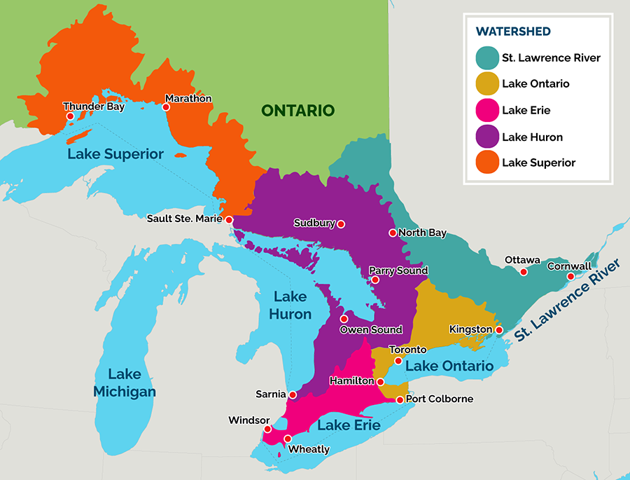
The Great Lakes and St. Lawrence River Basin in Ontario
The map shows the five Great Lakes, four of which are in Ontario (Lakes Ontario, Erie, Huron and Superior), and the St. Lawrence River. Coloured shading is used to show each of the watersheds of the respective lakes and river.
Lake Superior
A recent example of continued progress on addressing legacy contaminated sediments in the Great Lakes is the application of a thin-layer sediment cap to Jellicoe Cove, the area with the highest mercury concentrations, in the Peninsula Harbour Area of Concern in Lake Superior (Anishinaabewi-gichigami in the Anishnaabewowin language). The Harbour is identified as an AOC due to historical inputs from the pulp mill and chlor-alkali plant, and log booming. Decades of industrial activity has resulted in elevated levels of mercury and polychlorinated biphenyls (PCBs) in sediment. The science indicated that a 15–20 cm sand cap over the contaminated sediment would accelerate natural recovery of the site by 75 years. Since its application in 2012, monitoring has shown that the cap has been effective and met the objectives of the remedial effort. It reduced the movement of mercury and PCBs to the overlying waters and the exposure of aquatic organisms to mercury in sediment, which is below the clean-up target. As a result, the Degradation of Benthos Beneficial Use Impairment was redesignated in January 2022 to “not impaired.” In addition, two other impairments to the AOC — Degradation of Fish and Wildlife Populations, and Loss of Fish and Wildlife Habitat — were designated “not impaired” in 2021.
Lake Huron
Since 2010, Ontario, Canada, municipalities, conservation authorities, non-governmental organizations and others have worked together to coordinate actions to protect and improve water quality along the southeast shores of Lake Huron. The Healthy Lake Huron Initiative aims to reduce the amount of nutrients and bacteria entering the water in six priority watersheds. Since 2018, over 75 projects and approximately $4 million dollars have been invested in the area. Examples of recent projects include the installation of stream buffers, berms, and use of cover crops to reduce soil loss and improve soil health; septic system inspections and upgrades; and restricting livestock from streams. Outreach and education are undertaken through annual newsletters, a projects website, landowner workshops and one-on-one visits and demonstrations. Long-term monitoring in these watersheds shows some improvements over time.
Lake Erie
First Nations have a strong cultural and spiritual connection to Deshkan Ziibi (from the Anishnaabewowin language), or the Thames River, which flows into Lake St. Clair and is part of the Lake Erie basin (Waabishkiigoo-gichigami). The Thames River Clear Water Revival (TRCWR) is a long-running partnership between the First Nations with traditional territories in the watershed, the City of London, the Lower Thames Valley Conservation Authority, the Upper Thames Conservation Authority, Ontario and Canada. Ontario has supported a number of TRCWR projects, most notably a First Nations Youth Program launched in 2015 to: provide First Nations youth with an awareness and appreciation of work opportunities in the environmental field; improve connections between communities; and advocate for environmental issues. The information gathered as a part of this initiative also informed a 20-year plan to protect and restore the watershed water quality and quantity, while supporting economic and urban development.
Lake Ontario
Within the Hamilton Harbour AOC in Lake Ontario (Niigani-gichigami), Randle Reef sediment is highly contaminated with polyaromatic hydrocarbons (PAHs), as a result of over 150 years of historical industrial inputs. There is an ongoing $139 million restoration project to contain the contaminated sediment in an underwater steel box. Hydraulic dredging of the contaminated sediment was completed in October 2021. The project will be entering its final phase, with the installation of the isolation cap for the steel box. The project is funded by Canada, Ontario and local partners. When the project is completed in 2024, the environmental, economic and social benefits will be numerous, including improved fish and wildlife habitat, reduced spread of contaminants through the harbour, enhancement of recreational, shipping and port opportunities, and an estimated economic impact to the community of $126 million in job creation, business development and tourism. The project is also essential to delisting Hamilton Harbour as an AOC.
St. Lawrence River
The St. Lawrence River, or Kaniatarowanenneh in the Kanien’kéha language, has a significant connection to the cultural identity and rich history for Indigenous peoples that have lived along the river for millennia. The Mohawk community of Akwesasne, meaning Land Where the Partridge Drums
is located along the river in Akwesasne, near Cornwall, Ontario, which is an AOC. One of the most harmful aspects of the contamination in the St. Lawrence River was the fear it created among Akwesasr:onon to engage in practices with the water, fish, and land. The maintenance of Akwesasr:onon cultural knowledge and values is contingent on being connected with the land through land-based practices. In 2021, Ontario and Canada funded a project called “St. Lawrence/Cornwall Area of Concern — Fish Consumption and Sampling Community Input” to analyze fish species of interest for contaminants and provide up-to-date information on contaminant levels for Akwesasne to review and distribute to the community. The project also supports the facilitation of workshops that will include open discussions about fish species of interest, environmental fears, cultural responsibilities to the fish, and what is needed to repair the disconnect between Akwesasr:onon and the water and fish. The project will help determine if consumption of fish and wildlife is still impaired within the St. Lawrence River AOC.
Following many months of negotiations, on May 27, 2021, Canada and Ontario signed the 9th Canada-Ontario Agreement on Great Lakes Water Quality and Ecosystem Health, marking more than 50 years of collaboration between Canada and Ontario to improve conditions in the Great Lakes. The 2021 COA sets out specific actions that each government will take as they work together to restore, protect and conserve the water quality and ecosystem health of the Great Lakes. The 2021 COA outlines new and ongoing actions to safeguard the world’s largest freshwater lake system, such as improving wastewater and stormwater management, managing nutrients, reducing plastic pollution and excess road salt, restoring native species and habitats and increasing climate resilience. The agreement also includes a new focus on protecting Lake Ontario and supporting nature-based recreation opportunities.
In addition, Ontario is committed to both new and continued actions to support engagement of First Nations and Métis partners as they continue to provide local community context, knowledge, expertise and resources that help to inform future collaborative efforts for Great Lakes restoration, protection and conservation. The 2021 COA maintains the specific First Nations and Métis Annexes introduced in the 2014 COA, directs all Annex Leads to collaboratively engage First Nations and Métis partners in the delivery of Annex commitments, as appropriate, and makes a series of new commitments throughout the agreement.
Building awareness
Ontario works to increase awareness of the Great Lakes by forging new partnerships between conservation authorities, non-governmental organizations and school boards. Educational events such as mini-water festivals, virtual field trips, student conferences and multi-day student summits have been co-created and delivered by partners since 2016. Recently, Ontario adapted its Great Lakes student/teacher conference model to fund virtual field trips to the Great Lakes, which supported Ontario’s switch to remote learning. The virtual field trips include: Lake Superior, Georgian Bay/Lake Huron, the Lake Huron/Lake Erie connecting channel and Ottawa River/St. Lawrence River.
Ontario’s provincial parks provide a way for many people to interact with and enjoy the Great Lakes. Over 20 parks in the Great Lakes Basin have senior interpretative naturalist staff who deliver programs to hundreds of thousands of visitors each year.
Ontario Parks recently partnered with Canadian Geographic to produce giant floor maps and lesson plans for use as a teaching resource, one of which highlights Ontario’s waterways and the Great Lakes. In addition, Ontario Parks’ Discovery School Program reaches tens of thousands of children annually, and parks along the Great Lakes such as Pinery Provincial Park and Bronte Creek Provincial Park host school group field trips.
Supporting community action
Ontario launched the first round of the Great Lakes Local Action Fund in September 2020 to support local projects that protect and restore coastal, shoreline and nearshore areas of the Great Lakes and their connecting rivers and streams. In 2021, 44 projects were selected to receive funding totaling $1.9 million over two years. The projects are led by community-based organizations, municipalities, conservation authorities and Indigenous communities and organizations across Ontario, from Ottawa to Thunder Bay. Some of the recipients include:
- ALUS Norfolk, who worked with farmers to restore land to reduce agricultural impacts on Lake Erie
- the City of Pickering, in collaboration with 50 community and youth groups, cleaned up litter along the shorelines and tributaries of Lake Ontario
- Manitoulin Streams Improvement Association, in partnership with Wiikwemkoong Unceded Territory, worked to restore habitat, improve water quality and clean up the shoreline of a Lake Huron tributary
- I-Think developed a Great Lakes Challenge Kit, which trains teachers on expanding teaching practices to include Great Lakes issues in student lessons
On February 7, 2022, Ontario announced an additional $1.9 million investment in the Great Lakes Local Action Fund. This new investment will support local projects led by community-based organizations, small businesses, municipalities, conservation authorities, and Indigenous communities and others that focus on protecting and restoring coastal, shoreline and nearshore areas of the Great Lakes and its connecting rivers and streams.
Read the measuring progress section of this report for more information on Ontario’s progress in engaging and empowering communities in the Great Lakes.
Goal 2: Protecting water for human and ecological health
The purpose of this goal is to protect human health and well-being through the protection and restoration of the ecological health of the Great Lakes Basin. The strategy includes actions to:
- manage and protect drinking water
- identify and mitigate impacts to water quality
- manage water usage and adapt to lake level changes
Management and protection of drinking water
Collaboration with municipalities, conservation authorities, source protection committees and others to support effective and ongoing implementation of source protection plans is a key commitment in the strategy to manage and protect drinking water. As highlighted in the Minister's annual report on drinking water (2021), implementation of 38 collaborative, watershed-based source protection plans that protect existing and future sources of drinking water is underway across Ontario. These plans contain policies to address certain activities identified as threats to drinking water sources, which include the Great Lakes. Approximately 39% of surface water drinking water systems which connect to the Great Lakes are included in source protection plans.
For example, the Essex Region Source Protection Area has formally identified the toxin produced by blue green algae, called microcystin-LR, as a drinking water issue at all Lake Erie drinking water intakes. The identification of activities and areas that contribute to this issue are being considered through the source protection plan, and can be adapted if required in the future.
In addition, the Credit Valley — Toronto and Region — Central Lake Ontario Source Protection Plan includes policies to specify actions to mitigate spill risks from fuel storage, pipelines, and nuclear power generation.
In 2017, an approach was added to the Technical Rules made under the Clean Water Act, 2006 to allow individual source protection committees and authorities to better identify water quality risks to drinking water systems in larger water bodies such as the Great Lakes that can be more vulnerable to contamination in a nearshore environment. In 2021, further changes were made to the Technical Rules to consider climate change risks, improving the risk-assessment approach to better identify risks associated with road salt, and the handling and storage of toxic chemicals.
To help ensure communities and landowners with drinking water systems not covered by provincially-approved source protection plans have the tools they need to continue to protect their drinking water sources, the province released new best practices for source water protection on ontario.ca on February 18, 2022. The new user-friendly best practices provide easy-to-understand information and tips to help private landowners, such as farmers and cottagers, First Nations communities, and communities protect drinking water sources from contamination. This includes ensuring a septic system is functioning properly and that on-site fuel tanks and pesticides are stored safely.
First Nations Drinking Water
The Ontario Clean Water Agency (OCWA) has established a First Nations Advisory Circle to gain a greater understanding of the broader water issues facing First Nations communities from an Indigenous perspective. The Advisory Circle, which reports to OCWAs Board of Directors through the Board’s First Nations Committee, meets at least four times annually and is comprised of a diverse group of individuals that identify as Indigenous, representing a variety of backgrounds, experiences and communities. The Advisory Circle provides advice and recommendations on the integration of First Nation perspectives into the OCWAs strategies and how the OCWA can enhance its partnerships with First Nations communities to better support their water and wastewater needs and concerns. The goal of the Advisory Circle is to provide a better understanding of the challenges that First Nations face, not only with respect to addressing water and wastewater treatment in their communities, but also in the context of their unique experiences, culture and history in Canada. The OCWA is committed to strengthening its current First Nations partnerships and developing new partnerships based on mutual trust, respect and collaboration.
Through the Walkerton Clean Water Centre (WCWC), Ontario has also been working with First Nations on the development of training programs to support operators, managers and community leaders in maintaining safe drinking water systems. Between April 2017 and March 2022, 167 individuals successfully completed the Entry-Level Course for Drinking Water Operators for First Nations,
and 116 successfully completed Managing Drinking Water Systems in First Nation Communities.
This training is provided in-kind and at no cost to the communities. WCWCs courses help build capacity and have been positively received by First Nation participants and communities, who we have heard want to see this relationship continue.
Read the measuring progress section of this report for more information on Ontario’s performance in ensuring drinking water in the Great Lakes Basin meets a high standard of safety.
Identifying and monitoring impacts to water quality
Research and monitoring are needed to identify impacts to water quality to inform management actions. The strategy commits Ontario to work to address water quality issues, including harmful and nuisance algal blooms, as well as toxic chemicals of emerging concern. Since the first progress report in 2016, Ontario has continued to invest in and support activities to identify and understand impacts to water quality in the Great Lakes Basin.
Collaborative Lake St. Clair and Thames River water quality study
Ontario, in partnership with Canada, collaborated with the U.S. National Oceanic and Atmospheric Administration, Great Lakes Institute of Environmental Research and Lower Thames Valley Conservation Authority to assess the water quality of Lake St. Clair and the Thames River. This multi-year collaborative study confirmed the presence of harmful algal blooms, which can occur extensively along the Canadian shoreline of Lake St. Clair and the lower Thames River.
Lake Erie phosphorus studies
Studies by the Ontario Geological Survey, the Ministry of Natural Resources and Forestry, the Ministry of the Environment, Conservation and Parks and additional partners examined levels of phosphorus in Lake Erie and its tributaries, as well as modelled lake-wide phosphorus and annual internal phosphorus loading, to enhance understanding of conditions in the lake and the role of nutrients in causing algal blooms.
Urban impacts studies
Recent studies in Lake Ontario by the Ministry of the Environment, Conservation and Parks used monitoring data and modelling to examine water quality, nutrient patterns and lake circulation to develop a proposed study framework to assess urban effects on the lake and the interaction of the land and water, and to help support the design of solutions.
The Multi-Watershed Nutrient Study
The Multi-Watershed Nutrient Study was conceived as a response to algae blooms and other signs of excess nutrients in the Great Lakes.
The main goals of the study included investigating the changes from the 1970s to today in:
- Diffuse sources of nutrients from agriculture
- The relationship between agricultural land use / management and nutrient inputs to water bodies
- Seasonal patterns of nutrient inputs to water bodies
- The types and ratios of phosphorus that are coming from agricultural landscapes
In addition, the study was designed to gauge the scope for change in the amount of nutrients coming from diffuse agricultural sources.
The study included:
- 4 continuous measurements
- 11 sentinel watersheds
- 15 million+ data points
- 55 tests per water sample
- 1800+ water sampling events
- 8 meteorological stations
- 10 parameters per station
- 5 years of sampling
- 3 university partners
- 12 research projects
Early findings of the study show that compared to a similar study in the 1970s:
- Nutrient inputs to water bodies have increased overall at most study sites
- Inputs of nutrients to water bodies have shifted to being mainly during the non-growing season in many areas, instead of the growing season as before
- More water is moving through some watersheds now
- There is now better information to model nutrient information in Ontario
Pesticides in stream water
Ontario’s Pesticide Concentrations in Stream Water study analyzes approximately 500 pesticide compounds in 18 Great Lakes tributaries dominated by agricultural land use. The results from this program have the potential to demonstrate the effectiveness of watershed management programs, policies and regulations, and illustrate areas where continued vigilance is needed.
Polychlorinated biphenyls (PCBs) monitoring
Ontario’s Great Lakes monitoring has demonstrated that concentrations of PCBs in sediments have declined in some nearshore areas of Lake Ontario since 1994. On average, levels of PCBs in sediments at the sixteen sites that were sampled over this time period have decreased by half, and there were significant improvements in some Areas of Concern, such as the Toronto Inner Harbour. However, there are areas where PCB concentrations remain elevated, particularly in areas closer to shore and near urban areas. The data suggests that concentrations of PCBs in Lake Ontario surface sediments should continue to decline with reduction of inputs to the lake.
New technologies to support monitoring
New techniques and technologies have also been used to support monitoring efforts. For example, real-time monitoring buoys deployed in the nearshore of Lake Erie and Lake Ontario provide an opportunity for early warning of water quality issues. Recently, data from monitoring buoys are being made available via a new data sharing platform called Seagull. Making the data accessible through this platform will facilitate its use by researchers in both Canada and the U.S. — for example, the U.S. National Oceanic and Atmospheric Administration recently used this data to develop a model to help predict movements of low-oxygen water in Lake Erie, which can impact fish populations and water quality at drinking water intakes.
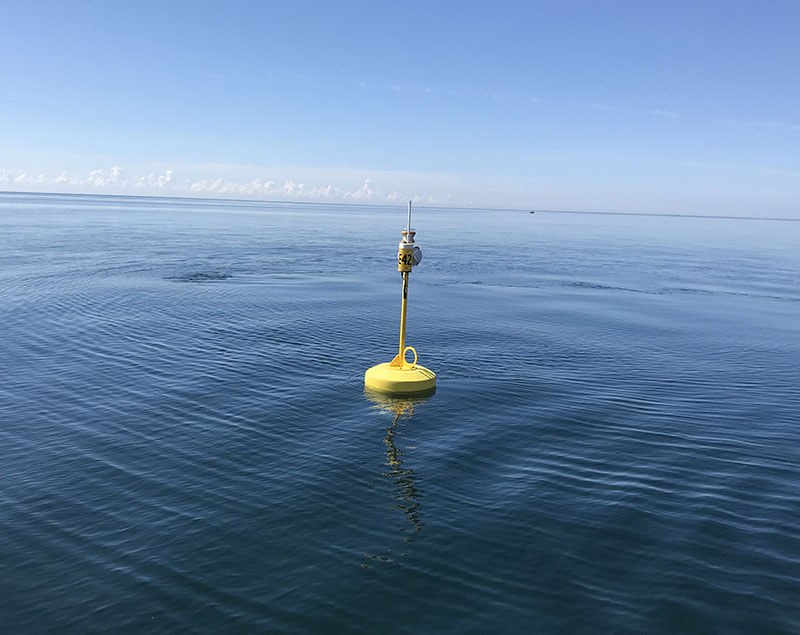
A real-time monitoring buoy in the nearshore of Lake Ontario
In addition, the use of passive samplers has enhanced monitoring of contaminants of ongoing and emerging concern. Passive samplers are devices that can be placed and left in water or sediment to assess concentrations of chemicals. These devices have been used at Great Lakes long-term monitoring sites and watersheds, to track down sources of legacy contaminants such as PCBs in Hamilton Harbour, for monitoring historical contaminants in the Niagara River region, and evaluating the effectiveness of remediation in Peninsula Harbour. Passive samplers are also very useful for enhancing monitoring for contaminants of emerging concern, such as flame retardants, pharmaceuticals, and pesticides, and their use has allowed us to screen for unknown contaminants and prioritize for further assessments, such as contaminants from the breakdown of tires.
Actions to protect and restore water quality
Protecting and restoring water quality requires action on multiple fronts. The strategy strategy includes sixteen commitments to reduce stormwater and wastewater impacts, reduce excessive nutrients, and protect water quality by reducing toxic chemicals and other pollutants such as salt and plastic.
Excess phosphorus
Addressing threats to the water quality of the Great Lakes requires sustained, collaborative effort. When excess amounts of phosphorus from urban stormwater and farmlands enter waterways, for example, this can lead to the growth of algal blooms, which is currently threatening the water quality of water bodies like Lake Erie. To address this, the strategy commits Ontario, with Canada and implementation partners, to develop and implement an action plan to reduce phosphorus loads to Lake Erie.
Under the Great Lakes Protection Act, 2015, Ontario committed to a 40% phosphorus load reduction target for Lake Erie. This 40% phosphorus reduction target was established through a binational science process for the western and central basins of Lake Erie to address harmful algal blooms in the western basin and hypoxia in the central basin.
The Canada-Ontario Lake Erie Action Plan to reduce phosphorus loadings to Lake Erie was released in 2018 and identifies more than 120 actions to help achieve the phosphorus target, such as better management of wastewater and stormwater discharges, using best management practices to keep phosphorus on farmland and out of waterways, restoring natural heritage features such as wetlands, improving monitoring and science, and enhancing communication and outreach. Almost half (46%) of the actions in the Lake Erie Action Plan are designated for the ministries of Environment, Conservation and Parks, Natural Resources and Forestry, and Agriculture, Food and Rural Affairs.
Through the Canada-Ontario Lake Erie Action Plan, Ontario works with Canada and partners to implement actions towards the phosphorus reduction targets, which complements U.S. efforts to achieve binational phosphorus reduction targets for the lake. See the measuring progress section of this report for more information on progress to date in Lake Erie.
Excess salt
As reported in the last progress report, excess salt also has a negative impact on water quality in the Great Lakes Basin. A recent analysis of Ontario’s long-term chloride (an indicator of salt) data found that many monitoring locations near roadways or in urban areas exceeded the chloride water quality guideline. To act on this issue, the Ministry of Transportation’s Salt Management Plan was reviewed and updated in 2017 and now includes proven and science-based best management practices to ensure the optimal rate, timing, and location of salt application on roads. The plan ensures the best available winter maintenance practices are implemented to ensure safe driving conditions on the provincial highway network while minimizing environmental impacts.
In addition, the province works with stakeholders across Ontario, Canada and the U.S. to invest in research to understand new products and practices to deliver snow and ice control that reduce road salt usage and mitigate environmental impacts while maintaining public mobility and safety on provincial highways. Ontario has also conducted extensive research into winter materials over many years that has led to changes in winter maintenance standards and best practices, such as using pre-treated salt at lower application rates in place of dry salt.
In spring 2022, the Ministry of the Environment, Conservation and Parks held workshops with a range of stakeholders to seek input on the role of best practices in reducing excessive salting on Ontario’s roads, parking lots and sidewalks. The sessions offered a lot of helpful input and insights, including factors driving overapplication and key obstacles and challenges experienced by industry in adopting leading practices. The ministry is considering the feedback to help inform any next steps.
Collaboration and support from the Province of Ontario has been instrumental to Pollution Probe’s work related to addressing plastic pollution in the Great Lakes, which includes establishing and expanding the Great Lakes Plastic Cleanup, the largest initiative of its kind in the world aimed at preventing and removing plastic debris from the lakes. We look forward to continuing to work together for the benefit of our Great Lakes and the communities that rely on them.
Christopher HilkeneChief Executive Officer, Pollution Probe
Improvements to wastewater and stormwater management
As stormwater and wastewater are major conveyers of pollution, improvements to their management can have significant, tangible impacts on the water quality of the Great Lakes. The strategy includes four commitments to reduce stormwater and wastewater impacts to the Great Lakes, including assisting communities in reducing the volumes and impacts of stormwater; working with municipalities on solutions to minimize discharges of untreated sewage; and reducing the impacts of treated wastewater by working with communities and stakeholders to update policies, manage water infrastructure assets, and optimize wastewater treatment plants.
In addition to the Green Stream of the Investing in Canada Infrastructure Program, Ontario has used multiple avenues to invest in improvements to wastewater and stormwater systems around the Basin:
- Under the Ontario Community Infrastructure Fund program, eligible communities receive stable and predictable funding to support core infrastructure priorities including road, bridge, water and wastewater (includes stormwater) projects. Wastewater projects are assessed on various criteria including minimizing discharges of raw sewage by rehabilitating or developing new wastewater infrastructure. As announced in the 2021 Ontario Economic Outlook and Fiscal Review, Ontario is increasing the Ontario Community Infrastructure Fund by $1 billion over the next five years ($200 million per year) beginning in 2022.
- The Ontario government is providing nearly $10 million in funding to provide support for wastewater monitoring and public reporting, to improve transparency around monitoring and public reporting of sewage overflows and bypasses from municipal systems. The government is also providing $15 million in capital funding to improve the management of wastewater and stormwater discharges into the Lake Ontario basin.
Ontario also continues to support local groups and programs to improve management of wastewater. For example, the Grand River Watershed-Wide Wastewater Optimization Program provides wastewater treatment optimization technical support to wastewater operators and managers, and reports on improvements in the quality of wastewater discharges in the Grand River watershed. In addition, Ontario invested in optimization projects at wastewater treatment plants in Sarnia, Oxford County and Leamington, and facilitates a group of wastewater managers to regularly discuss optimization at wastewater treatment plants.
Inadequate readiness for storm events can have environmental, social and economic impacts. The insurance industry tells us that water damage from extreme weather events, such as flooding, is the key factor behind growing insurance costs. These losses across Canada averaged $405 million per year between 1983 and 2008, and have more than doubled to $1.8 billion per year between 2009 and 2017. While conventional stormwater management infrastructure can be costly, low impact development (LID) can be a cost-effective way of managing stormwater runoff because it can potentially generate a $1.60 to $2.40 return on the investment, with benefits including aesthetics, recreation, air quality, local climate regulation, improved water quality and avoided economic costs (such as stormwater treatment, mitigation costs). In order to improve our readiness, Ontario is taking a number of steps to reduce barriers for stormwater managers.
In January 2022, a draft Low Impact Development Stormwater Management Guidance Manual was posted on the Environmental Registry for public comment. The purpose of this draft manual is to provide guidance for stormwater managers on reducing stormwater volume and associated contaminant release into waterways. This will be an important step for reducing barriers to adoption of innovative, adaptation technologies for stormwater management. Ontario is committed to protecting our lakes, rivers and groundwater supply, now and for future generations. Ontario sought public input on:
- a discussion paper on potential opportunities and approaches to improve municipal wastewater and stormwater management and water conservation
- a proposed subwatershed planning guide to help municipalities and other planning authorities with land use and infrastructure planning
Another initiative that complements the overall approach for stormwater management is the proposed regulatory changes under the Ontario Water Resources Act to exempt certain low risk sewage works from requiring an environmental compliance approval (ERO 019-4456 October 25, 2021). The proposed changes, if implemented, would reduce red tape and make it easier to build LIDs by removing the need to obtain an environmental compliance approval for stormwater management LIDs located on single private residences.
Ontario funded the Lake Simcoe Region Conservation Authority in partnership with Sustainable Technologies Evaluation Program, to advance a best practice
training program for stormwater infrastructure maintenance and inspections. Municipal stormwater management inspector training has been provided to over 100 municipal participants from the Lake Simcoe watershed and across Ontario in 2021.
Agricultural stewardship and best management practices
Ontario agriculture and agri-food sectors are an important economic engine for the province and contribute to our quality of life by providing good jobs, safe and secure food and contribute to Ontario’s economic success. Ontario provides assurance and oversight of the agri-food system to protect the productive capacity of our natural resources and support sustainable actions. Best management practices help to minimize the risks of excess nutrients to the Great Lakes. Ontario delivers agri-environmental stewardship programming to assist Ontario producers in managing soil and water impacts. The strategy commits Ontario to:
- improve understanding of the effectiveness of agricultural stewardship programs and practices
- encourage and strengthen the adoption of effective best management practices
- seek opportunities to reduce nutrient inputs to the environment and advance monitoring of agricultural best management practices in priority geographic areas and in agricultural production systems to enhance performance
Ontario provides technical support for farmers, watershed initiatives and industry groups, and invests in environmental stewardship activities to provide support to farmers in implementing best management practices. Conservation authorities and agriculture sector groups are also leading several initiatives across the Great Lakes Basin towards improving soil health and water quality. This includes one-on-one outreach, workshops and demonstration projects to increase the adoption of best management practices in high priority watersheds that will enhance water quality by reducing the excess loss of phosphorus from agriculture.
The first progress report on Ontario’s Great Lakes Strategy noted the initiation of the Great Lakes Agricultural Stewardship Initiative, funded through the Canada-Ontario initiative Growing Forward 2. This four-year initiative produced significant results for projects in Lake Erie and the southeast shores of Lake Huron, including:
- a total of $30.6 million invested — $10 million government and $20.6 million from farmers and custom applicators
- 1,300 environmental improvement projects on farms and 214 improvement projects for custom applicators of agricultural nutrients
- 850 Farmland Health Check-Ups, developed by farmers working one-on-one with participating technical experts
- establishment of six monitoring sites by conservation authorities to collect information on implementation of agricultural best management practices and water quality to evaluate effectiveness of practices for removing phosphorus
- 12 education and outreach projects with selected organizations implementing local projects to increase awareness of soil health and water quality within the agricultural community
While efforts are province-wide, there is a specific focus on the Lake Erie and Lake Simcoe watersheds, due to local water quality concerns and the dominance of agriculture production in these regions. Under the Canadian Agricultural Partnership’s Lake Erie Agriculture Demonstrating Sustainability initiative, farmers work one-on-one with a participating certified crop advisor or professional agrologist to identify best management practices tailored to the specific needs of their operation. This helps to increase farmers’ awareness of field-specific risks and supports them with a plan and financial support to take up practices that improve soil health and water quality. Across the province, between 2018 and December 2021, Ontario farmers completed approximately 1,840 projects representing an investment of approximately $58.7 million in on-farm environmental improvements ($18.8 million in cost-share funding from Canada and Ontario, and $40.4 million in farmer cash contributions). These projects:
- reduce the risk of soil loss from agricultural land through implementation of best management practices including planting cover crops, planting windbreaks and buffer strips and implementing erosion control structures
- improve management of agricultural land through modifications to tillage equipment to reduce soil disturbance and soil and nutrient losses
- improve placement of agricultural nutrients through modifications to equipment to reduce loss of nutrients from agricultural land
In addition, in 2021, Ontario created a new regulation under the Drainage Act to simplify processes for minor improvement projects that do not increase the risk of erosion, do not occur within existing wetlands, and do not enclose a drain. This update is expected to reduce costs and the time required for municipal authorization for some drainage projects that may include environmental benefits such as grassed waterways, sediment traps, and natural channel design features, which can improve water quality and reduce the frequency of floods.
Management of water usage and adaptation to lake level changes
The strategy makes five commitments to improve water quantity management, including working with the International Joint Commission (IJC) on managing lake levels, and assessing Ontario’s approach to manage water takings. As part of managing lake levels, Ontario continues to participate on the IJCs Great Lakes-St. Lawrence River Adaptive Management Committee, which undertakes monitoring and technical assessments to support the on-going regulation of water levels and flows. This work is coordinated annually within a multi-agency and binational adaptive management framework. Ontario contributes to elements of various priority research and monitoring activities identified by the committee, such as testing remote sensing products and geospatial data sets used to enhance detection of changes to the wetland vegetation of coastal areas of Lake Ontario and the Upper St. Lawrence River.
The strategy also commits to Ontario fulfilling its obligations under the Great Lakes-St. Lawrence River Basin Sustainable Water Resources Agreement (the Agreement) in cooperation with Quebec and the eight Great Lakes States. As part of its obligations, Ontario continues to report its water use data to the Great Lakes Regional Water Use database annually as well as submit an annual assessment of the provinces water conservation and efficiency programs to the Regional Body. In 2019, Ontario met its commitment to submit an every-five-year report on its water management program and also contributed to the development of a renewed Science Strategy which identifies priority actions for collaboration with regional partners in order to strengthen the scientific basis for sound water management decision-making under the Agreement.
To support assessment of the importance of groundwater systems for sustaining water quality and quantity in the Great Lakes and tributaries, approximately 26,000 square kilometers of aquifers within the Great Lakes Basin were recently mapped by the Ontario Geological Survey.
Ontario also took action in 2021 to strengthen protection of water resources by updating our framework for managing water takings in the province. Based on a comprehensive review of existing water taking policies, programs, science tools, and consultation with the public, stakeholders and Indigenous communities, the province made the following enhancements:
- required water bottling companies to have the support of their local host municipality before applying to the province for a permit for a new or increased groundwater taking
- established provincial priorities of water use that can guide decisions when there are competing demands for water
- put in place new, more adaptive approach for the ministry and water users to better assess and manage multiple water takings together in areas of the province where water sustainability is a concern in areas where water sustainability is a concern
- made water taking data that is reported to the province publicly available
To support the changes, the province provided new guidance on managing water takings in areas where water sustainability is a concern and where there are competing demands for water.
With these new rules and guidance in place, we can be confident that water resources in the province are protected by strong policies and managed sustainably for future generations.
Goal 3: Improving wetlands, beaches and coastal areas
The purpose of this goal is to protect and restore wetlands, beaches, shorelines and other coastal areas of the Great Lakes-St. Lawrence River Basin. The strategy includes commitments to:
- ensure and promote clean, safe shores
- protect and restore wetlands
- restore priority areas, such as AOCs
- use planning and policy tools, as well as best management practices to protect and restore these important areas in the Basin
Ensuring and promoting clean, safe shores
The strategy commits Ontario to work with public health units to improve the way beach water safety is monitored and assessed. Ontario’s public beaches are monitored regularly throughout the summer by public health personnel to assess water quality for the safe enjoyment of users. They do this by looking for conditions that might be hazardous or could pollute the water to an extent that would make it unsafe.
Routine monitoring is accomplished through testing of the recreational water for bacteria at a level that helps to determine its suitability for public use. In 2018, Ontario updated the Recreational Water Protocol and the Operational Approaches for Recreational Water Guideline to provide direction to boards of health on the delivery of local, comprehensive recreational water programs. The guidance includes:
- annual assessments, surveillance, inspection, and reporting of testing results of public beaches
- investigation and response to complaints of adverse events at public beaches
- encouraging the safe use and operation of public beaches through public health education tools
If the test results indicate that beach water quality is poor, the public health unit will inform the public of the status of the beach using the most appropriate method(s) of communication. These may include issuing precautionary notices at the beach, posting recreational water test results on the public health unit website, media releases and other forms of outreach. The Blue Flag program is promoted by regional tourism organizations in the province, particularly in southwestern Ontario, where four of the 26 Blue Flag beaches in Canada are located.
Read the measuring progress section of this report to read more about how the quality of Ontario’s Great Lakes beaches compares to previous years.
Protecting and restoring wetlands
The conservation of wetlands is an important part of improving the resilience of natural landscapes across Ontario. Wetlands purify our air and water, protect biodiversity and natural heritage, provide recreational opportunities and support First Nations and Métis traditional practices.
The strategy commits Ontario to supporting partnerships and collaborations to conserve and restore wetlands across the Basin. Since the first progress report, Ontario has made significant investment in protection and restoration of wetlands. For example:
- In 2017, the province matched $650,000 in federal funding through the Clean Water and Wastewater Fund to provide Ducks Unlimited Canada with $1.3 million to create 75 new wetlands and restore 17 existing wetlands in the Lake Erie basin in order to capture agricultural runoff and ultimately reduce the amount of phosphorus entering Lake Erie.
- Between 2016 and 2021, Ontario invested $1.75 million in the Eastern Habitat Joint Venture partnership through collaboration with Ducks Unlimited Canada, who has leveraged this support to over $5.5 million dollars for the protection of over 3,800 acres of wetland habitat and 9,900 acres of upland habitat primarily located in the Great Lakes Basin, as well as enhancement of an additional 3,400 acres of wetland and 212 acres of associated upland habitat.
- In 2020, Ontario announced an investment of $30 million over 5 years for wetland restoration and enhancement through the Wetlands Conservation Partner Program. Year 1 included approximately 60 wetland restoration and enhancement projects by Ducks Unlimited Canada. For Year 2, the program expanded to include agreements with six conservation organizations. From the first two years of this program, over $12 million has been invested in about 180 wetlands projects, restoring and enhancing over 4,200 acres of wetlands across the province.
In addition, in 2020, Ontario Regulation 454/96 "Construction under the Lakes and Rivers Improvement Act" was amended to provide alternative, optional rules for wetland dam owners to repair existing low hazard wetland dams without obtaining approval if they meet the requirements in the regulation. This allows eligible dam owners to benefit from cost savings and regulatory relief for wetland dam repairs while supporting the continued management of Ontario’s wetlands.
Restoration of priority areas
The strategy identifies seven actions for addressing other coastal areas in the Great Lakes Basin, including collaboration with partners on initiatives to improve nearshore areas, addressing key challenges in AOCs, and continuing to implement the Lake Simcoe Protection Plan.
Addressing concerns in priority areas across the Great Lakes Basin continues through implementation of the COA as well as other location-specific protection plans. For example, through investment by Ontario, Canada and the City of Toronto, the Toronto Waterfront Revitalization Initiative (2000–2028) aims to generate a thriving waterfront that can be enjoyed for generations. This initiative will transform 800 hectares of brownfield lands into sustainable mixed-use communities, with 25% of the revitalized area dedicated to waterfront parks and public spaces.
Recent work includes the development of the Don River Mouth Naturalization and Port Lands Flood Protection Project. This project will reduce flooding risk by naturalization of the Don River mouth through creation of new river channel and coastal wetlands, and will help with completing actions necessary to delist the Toronto and Region Area of Concern. The revitalization of Toronto’s waterfront is the largest urban redevelopment project underway in North America and is one of the world’s largest waterfront revitalization efforts ever undertaken.
Areas of Concern
Another priority for Ontario is the restoration of locations in the Great Lakes that were identified as having experienced high levels of environmental degradation. These are called Areas of Concern (AOCs). Through the 1987 Protocol of the Great Lakes Water Quality Agreement, 12 Canadian and 5 binational AOCs were identified.
To date, three Canadian AOCs have been delisted (Severn Sound, Collingwood Harbour, and Wheatley Harbour). Significant progress has been made in the restoration of the remaining Canadian and binational Great Lakes AOCs since the first progress report. For example, five Beneficial Use Impairments not impaired
in 2019 and one — Degradation of Phytoplankton or Zooplankton Populations — in 2020.
To learn more about how Ontario has made progress in cleaning up Great Lakes AOCs, read the measuring progress section at the end of this report. These online resources also provide more information about ongoing work in the remaining Canadian and binational AOCs:
- Bay of Quinte
- Detroit River
- Hamilton Harbour
- Jackfish Bay
- Niagara River
- Nipigon Bay
- Peninsula Harbour
- Port Hope
- St. Clair River
- St. Lawrence River
- St. Marys River
- Spanish Harbour
- Thunder Bay
- Toronto and Region
Lake Simcoe
Lake Simcoe (Zhooniyaang-zaaga’igan in the Anishinaabemowin language) and its watershed covers 3,400 square kilometers and is part of the Trent-Severn Waterway, which flows into Georgian Bay of Lake Huron. As an important component of the Great Lakes Basin, the strategy commits Ontario to continuing to implement the Lake Simcoe Protection Plan (LSPP). This includes ongoing monitoring of key environmental indicators, supporting research to better understand the stressors facing the lake, and identifying innovative solutions and encouraging their adoption through local partnerships. The Minister’s 10-Year Report on Lake Simcoe, released in July 2020, highlights some of the actions that the province and partners have taken to protect and restore Lake Simcoe, such as:
- restoration of more than 15 kilometres of degraded shorelines
- planting of more than 55,000 trees and shrubs
- creation and restoration of 120 hectares of wetlands
- 50% reduction in phosphorus loads from sewage treatment plants entering the lake
- plans developed for improved water and nutrient management on approximately 54,000 acres of cropland
Monitoring has shown that the amount of algae in Lake Simcoe has decreased over time, leading to improved water quality, which has remained stable through much of the watershed since the 2015 Five-Year Report. For the cold-water fish community, monitoring has shown that lake trout, lake whitefish, and cisco continue to successfully reproduce, although the wild populations of these species are dominated by only a few year classes (fish produced in the same year), and are at lower levels than historically. A legislated review of the LSPP began in 2019 and was publicly launched in December 2020, with significant engagement and consultation throughout 2021.
Planning, policies and best management practices
As committed in the strategy, Ontario has made progress in updating wetland data and mapping to support conservation efforts and assist municipal and shoreline planning. The Ministry of Natural Resources and Forestry developed the Great Lakes Shoreline Ecosystem, a classification and mapping tool to enhance and update the inventory, mapping and classification of terrestrial and wetland shoreline ecosystems in the Great Lakes.
The tool uses existing data and a standardized methodology to identify and map Great Lakes shoreline ecosystems, including all coastal and inland wetlands. This can be used to track progress towards conservation targets, monitor ecosystem change, assist municipal and shoreline planning, support conservation efforts such as habitat restoration and shoreline management, and improve our understanding of ecological processes.
Through updates to the Greenbelt Plan and A Place to Grow: A Growth Plan for the Greater Golden Horseshoe, municipalities are now required to consider the Great Lakes Strategy, the targets and goals of the Great Lakes Protection Act, 2015 and any applicable Great Lakes agreements as part of watershed planning activities. These updates include provisions such as:
- integration of watershed planning approaches, taking into consideration the goals and objectives of improving, restoring and protecting the Great Lakes
- new policies to identify water resource systems and provide protection for key hydrologic areas such as significant groundwater recharge areas, highly vulnerable aquifers, and significant surface water contribution areas
In addition to the above, the update to the A Place to Grow: A Growth Plan for the Greater Golden Horseshoe included a natural heritage system made up of natural heritage features and areas to provide connectivity and support natural processes.
Ontario is investing $12 million over three years (2021–2023) to support the Greenbelt Foundation’s ongoing work to help protect and restore the environmental and agricultural integrity of the Greenbelt area and enhance sustainable recreational and economic opportunities through several programs, including a grant funding program. Projects delivered through provincial funding will focus on three priority objectives: planting trees to increase natural cover, enhancing recreational opportunities for people to experience nature, and maintaining and enhancing green infrastructure and climate resilience. Examples of these projects include:
- enhancements to 1,200 kilometers of the Greenbelt to Lake Ontario waterfront cycling loop to increase recreational cycling and tourism, and contribute to Ontario’s rural economies with the expansion of six new connector routes
- advancing natural infrastructure in the Greenbelt by increasing natural cover by planting approximately 500,000 trees on private lands over two planting seasons
Goal 4: Protecting habitats and species
The purpose of this goal is to protect and restore the natural habitats, biodiversity and resilience of the Great Lakes-St. Lawrence River Basin. The strategy includes actions to protect and restore species through tools such as habitat restoration, and reduce the introduction and spread of invasive species.
Protecting habitats and species
Assessing the status and improving our understanding of factors affecting the health of aquatic ecosystems, habitats, native species and food webs is a component of Goal 4 under the strategy. Protecting the habitats of the Great Lakes Basin and the plants and animals that live there can be a complex and challenging task, requiring dedicated research and monitoring to better understand relationships and impacts for effective management and protection.
Muskrat in the Great Lakes
A multi-year project by Ontario’s Ministry of Natural Resources and Forestry determined that muskrat populations were very low in many Lake Ontario coastal wetlands and appeared to be influenced by lake-wide water level management in that basin. Future work will examine additional components of muskrat habitat, such as the type and density of vegetation and the presence of invasive species like Phragmitesand hybrid cattails. Muskrats provide a variety of ecosystem services in wetlands and their populations can serve as an indicator of wetland health. The results of this work will support the early evaluation of the International Joint Commission’s new water-level regime, and will provide greater knowledge of Great Lakes coastal habitats and ecosystems that is needed to protect these habitats and the species that reside within.
River-spawning Lake Trout populations
The strategy commits Ontario to continue the rehabilitation and maintenance of native Great Lakes species. Native populations of Lake Trout (Salvelinus namaycush) in the Great Lakes suffered catastrophic collapses in the mid-20th century due the impact of human activities as well as ecosystem stressors. Among the populations that collapsed were river-spawning Lake Trout populations that were known to swim up more than a dozen Lake Superior tributaries each fall.
As these populations collapsed, efforts by the Ontario Ministry of Natural Resources and Forestry were made to preserve this unique type of Lake Trout in a chain of sanctuary lakes followed by years of stocking to restore the population. Ongoing work by Ontario since the 1970s has documented the successful restoration of a wild reproducing population spawning in the Dog River. The use of radio telemetry is providing information on the timing of spawning, and genetic analysis of eggs has confirmed the locations where spawning occurs, and the habitat preferred by spawning Trout.
Until recently, the Dog River was the only Lake Superior tributary known to have a spawning Lake Trout population. However, during an assessment of several eastern Lake Superior tributaries in the fall of 2021, Lake Trout in spawning condition were discovered in the Pukaskwa River potentially representing a second previously unknown river-spawning population. This positive discovery is a welcome success in Ontario’s continued work to protect and restore the species of the Great Lakes.
Fish behaviour and movement
In addition, Ontario has undertaken work to better understand the behaviour and movements of various fish species to support fisheries management and restoration efforts using the Great Lakes Acoustic Telemetry Observation System. In Lake Ontario, Ontario and academic partners have tracked tagged Lake Whitefish, Cisco, and Bloater in eastern Lake Ontario, revealing the behavior and seasonal movements of these fish. The use of acoustic receivers in Lake Superior’s Black Bay from 2016 to 2021 is providing information on Walleye migratory behaviour and location and timing of spawning, particularly in important spawning tributaries.
Ontario continued ongoing projects to track movements of Walleye in the Grand River, Lake Whitefish in Lake Erie, and Muskellunge in Lake St. Clair. New tracking projects were also undertaken for Walleye in the Thames River, Burbot in the east basin of Lake Erie, as well as expansion of the tracking area in Lake Erie’s east basin, the Thames and Grand Rivers, and Lake St. Clair.
Greenlands Conservation Partnership
In 2021, Ontario invested $20 million over four years in the Greenlands Conservation Partnership to help secure land of ecological importance and promote healthy, natural spaces. The funding will enable the Nature Conservancy of Canada and the Ontario Land Trust Alliance to conserve, restore and manage natural areas such as wetlands, grasslands and forests. This initiative will help mitigate the effects of climate change and increase the number of conserved natural spaces for the public to enjoy. Some key areas that have been secured with contributions from Greenlands funding include Michael’s Bay and Vidal Bay on Manitoulin Island, Brighton Wetlands, Alfred Bog near Ottawa and the Auzins Nature Sanctuary near London.
Protected areas
Ontario has published a series of indicator reports on the state of Ontario’s protected areas, and continued reporting on the general state of the environment, resource management and landscape planning. In 2020, the Ministry of Natural Resources and Forestry and Ministry of the Environment, Conservation and Parks completed technical work for a data set of information on all natural heritage and protected areas in Ontario, including the Great Lakes. Protection of Ontario’s natural heritage and biodiversity conservation is also supported by reporting sightings of animals and plants of conservation concern, wildlife concentration areas, plant communities, and natural areas in Ontario to the Natural Heritage Information Centre.
Through Ontario’s Greenlands Conservation Partnership, the Nature Conservancy of Canada and the Province have delivered 31 key conservation projects and protected over 164,200 hectares of lands and waters across Ontario. These protected areas will remain a home for wildlife, a haven for recreation, and a vital resource that cleans our air and water, while protecting communities against the impacts of climate change and biodiversity loss. We sincerely appreciate the work that has led to this important investment for all Ontarians.
Mike HendrenRegional Vice President, Ontario Nature Conservancy of Canada
Read the measuring progress section of this report to read more about how Ontario has made progress in protecting habitats and native species.
Taking action on invasive species
Ontario is strengthening its efforts to protect the province’s natural environment and economy from the threat of invasive species. On January 1, 2022, new rules for 13 invasive species and watercraft as a carrier of invasive species came into effect. The new invasive species regulations add five additional aquatic invasive species:
- Tench
- Marmorkreb
- New Zealand Mud Snail
- European Frog-bit
- Yellow Floating Heart
Ontario has now regulated all 21 species included in the Great Lakes and St. Lawrence Governors Premier’s list of Least Wanted Aquatic Invasive Species, helping to protect the shared ecosystems and economies in the Great Lakes Basin. The regulation of overland transport of watercraft, is the first regulation of its kind, in Ontario and will help prevent the spread of aquatic invasive species within the Great Lakes as well as to inland waters in the province.
One commitment in the strategy is to develop scientifically defensible surveillance activities in areas at high risk of invasive species introductions. Ontario is continuing early detection and response actions for high-risk invasive species to prevent their spread to new waters and impacts to biodiversity and the provincial economy.
For example, community Environmental eDNA testing at sentinel sites across the Great Lakes allows for early detection of invasive species that are not currently being looked for and will potentially enable rapid responses before they can become established. Initial studies using this technique have detected aquatic invasive species in waters flowing into or adjoining the Great Lakes, such as Rudd in the Grand River. Sites across the Great Lakes that have been identified as potential entry points for invasive species will be seasonally sampled to develop an eDNA
metabarcode
, or a baseline characterization of the community of fish and other aquatic organisms present at that point in time. Comparison of the eDNA metabarcode at a location from one time period to the next will enable early detection of not only known aquatic invasive species, but also others that are not currently known to be in the Great Lakes Basin.
Other actions on invasive species include:
- In 2020, Ontario’s Ministry of Natural Resources, and Forestry developed prevention and response Plans for European water chestnut and water soldier, which are prohibited species under the Invasive Species Act, 2015.
- Ontario worked with Parks Canada Agency, the Ontario Federation of Anglers and Hunters, Ducks Unlimited Canada and other partners to control water soldier in the Trent Severn Waterway, and European water chestnut in the Rideau Canal and in Lake Ontario, and at the Welland River. Rapid response efforts led by Ontario Federation of Anglers and Hunters were also undertaken at Red Horse Lake (in the Gananoque River watershed of the St. Lawrence River).
- Ontario and Canada continue to conduct surveillance for invasive carps within high priority areas within the Great Lakes including Lake Erie, and Lake St. Clair, utilizing techniques such as environmental DNA.
Read the measuring progress section of this report to read more about how Ontario has made progress in reducing the threat of aquatic invasive species to the Great Lakes.
Goal 5: Enhancing understanding and adaptation
The purpose of this goal is to advance science relating to existing and emerging stressors, such as climate change, that improves understanding and management of the Great Lakes-St. Lawrence River Basin. The strategy includes actions to:
- increase knowledge through the delivery and sharing of science
- prepare and respond to climate change by identifying risks and impacts, and identifying ways to mitigate, adapt and become resilient to climate change
Increasing knowledge through delivery and sharing of science
Research and monitoring are the cornerstones of the sound science that guides the protection and restoration of the Great Lakes. Long-term monitoring programs provide the platform upon which collaborative and integrated research is built to enhance our understanding of the Great Lakes. The strategy commits Ontario to deliver the needed science through collaboration and investment in research and monitoring. Since the first progress report on Ontario’s Great Lakes Strategy in 2016, Ontario has continued to support long-term monitoring as well as specific studies to advance our understanding of the environmental issues as well as the effectiveness of management actions.
Research and monitoring to understand ecosystems
Ontario leads several monitoring and research programs in the Great Lakes Basin, including:
- sediment, benthic invertebrates and water quality monitoring in the nearshore of the Great Lakes
- water quality monitoring at Great Lakes drinking water intakes
- stream water quality monitoring via the Provincial Water Quality Monitoring Network
- monitoring of groundwater levels and chemistry via the Provincial Groundwater Monitoring Network
- monitoring of water chemistry, physical conditions and biological communities in inland lakes
- water quality monitoring in Lake Simcoe
- algae monitoring in the Great Lakes, Lake Simcoe and other inland lakes
- biomonitoring at the base of the Lake Ontario and Lake Erie food web to understand the Great Lakes food webs and effects of ecological stressors
- fish contaminant monitoring in the Great Lakes and inland lakes
- monitoring programs to evaluate Ontario’s fisheries and provide opportunities to gather information on the biodiversity and health of aquatic environments, such as analysis of the early life history, growth and diet of Lake Whitefish and modelling of commercial harvest dynamics
- examining the effects of climate change on aquatic habitats, fish life history, and ecosystem function, and using water balance dynamics to identify vulnerabilities to climate change
- characterization of the genetic diversity of wild, introduced and mixed-ancestry fish populations and assessment of the effects of diversity and management practices on genetic structure
Data and information from these programs continue to further our understanding of the Great Lakes ecosystem. For example, in one study, provincial scientists and collaborators examined PCB contamination in Lake Ontario sediments over time and compared to fish consumption advisories for the area. While many factors such as the levels of organic carbon in sediment may be playing a role in basin-wide fish trends, PCB concentrations in sediments and fish were consistently highest in Hamilton Harbour.
In another study, monitoring data for the nearshore areas of the Great Lakes showed that changes in the types and numbers of invertebrates living on the bottom of Toronto’s Humber Bay were due to changes in sediment and water quality, as well as invasive species and human activities.
In addition, Ontario’s data has been crucial in assessing progress made in Areas of Concern as well as informing binational reporting. Sediment chemistry and benthic
Additionally, Ontario contributes data, information and expertise to development of State of the Great Lakes reporting under the Canada-U.S. Great Lakes Water Quality Agreement. For example, the Ontario Geological Survey provided groundwater chemistry data from more than 4,000 locations in the Basin to inform the updated Groundwater Quality Sub-Indicator Report. Ontario’s groundwater experts also participate in binational working groups to assess the water balance for the Basin and make future projections of climate and water use and are working to help municipalities and industry looking for sustainable groundwater resources.
Read the measuring progress section of this report to read more about how Ontario has increased public access to monitoring results and scientific information on the Great Lakes.
Improving effectiveness of agricultural best management practices
Ontario has invested in several initiatives with partners to improve knowledge on the effectiveness of agricultural best management practices and our ability to measure progress on reducing the loss of excess nutrients from agricultural operations. For example, the On-Farm Applied Research and Monitoring (ONFARM) program is a four-year applied research initiative that began in 2019 and runs until 2023 and is being delivered by the Ontario Soil and Crop Improvement Association (OSCIA). The program is funded by Canada and Ontario through the Canadian Agricultural Partnership, and is supported by a network of farmer cooperators, who are essential to the success of the program. ONFARM builds on the previous work started under the Great Lakes Agricultural Stewardship Initiative, funded under Growing Forward 2 by the federal and provincial governments from 2014–2018. The program is focused on three main pillars to increase Ontario and the agricultural sector’s knowledge of key environmental priorities, including:
- continuing water quality monitoring at seven sites in priority watersheds, as well as water quality modelling and examining the cost-effectiveness and impact of different agricultural best management practices
- establishing 25 on-farm paired soil health sites across the province where agricultural best management practices are applied across different regions, agricultural production systems and soil types, and identifying key soil health indicators for Ontario
- enhancing engagement opportunities with stakeholders to share results with a broader audience, which includes a stakeholder working group, annual research forums and establishing a network of demonstration farms across the province
The program offers incredible value to the province and the sector in building confidence and understanding of the effectiveness and impact of best management practices and how they can be successfully incorporated within agricultural production systems on various farms across the province.
Preparing for and responding to climate change
The strategy identifies several actions towards addressing climate change impacts and adaptation, including:
- continuing to build our understanding of climate change and its impacts
- undertaking an economic study to identify and quantify the economic impacts of climate change on the Great Lakes
- ensuring climate science information, including regional climate modeling data, is available to decision makers in Great Lakes communities to support planning
- working with partners to promote the use of adaptive management tools to encourage consideration of climate impacts in Great Lakes communities
- building climate change adaptation into agreements and programs
Identifying risks and impacts
In 2020, Ontario initiated a provincial-level, multi-sector assessment to examine the impacts of climate change on infrastructure, food and agriculture, people and communities, natural environment, and business and the economy. The assessment is considering how climate change will impact the natural environment, which includes consideration of water quality and quantity at a provincial scale. It will identify and assess how individual hazards such as drought and extreme precipitation will change over the coming decades. It will also help build awareness of climate impacts and potential solutions. Understanding the known and current impacts of climate change and identifying potential future impacts will help the province, municipalities, Indigenous communities and others make informed decisions that build resiliency within the province as well as the Great Lakes Basin specifically. The final results of the assessment are expected in 2023.
In addition to this assessment, Ontario has continued to lead and/or support projects that examine the effects of climate change to better inform planning and management around the Great Lakes Basin:
- Ontario provided funding to Zuzek, Inc. and its partners to enhance some of the technical work related to the study titled
Adapting to the Future Storm and Ice Regime in the Great Lakes,
which is part of a broader project funded by Natural Resources Canada to investigate the effects of climate change on coastal storms an ice cover, as well as integrate the findings into adaptation actions. Additional support was given to theRondeau Barrier Beach and Navigation Channel Advisory Committee
study to help enhance the Chatham-Kent Shoreline Management Plan. Collectively, this work will advance the knowledge base and enhance the adaptive capacity of practitioners managing the coastal zones and communities in the Great Lakes basin. The final reports for this work can be found at Adapting to the Future Storm and Ice Regime in the Great Lakes. - York, Victoria, and Calgary Universities and the Toronto and Region Conservation Authority are using artificial intelligence to create models that will improve understanding of climate change trends, risks, and vulnerabilities in the Lake Ontario basin. This work will also generate updated flood maps based on future climate projections and support the development of adaptative management actions to reduce flood risk and water quality deterioration.
- Ontario continues to support York University to maintain and improve the Ontario Climate Data Portal, which disseminates Ontario-specific high resolution regional climate projections based on the most up-to-date methodology using data from credible academic sources. Since its launch in 2018, the data portal has been used by a wide variety of practitioners to support the development of risk and vulnerability assessments, and climate change adaptation strategies. Ontario is also exploring other tools to help facilitate the communication and application of climate data and science to a broad range of stakeholders.
More broadly, Ontario continues to be an active voice in binational climate change conversations. In January 2020, the Great Lakes Commission formed a Standing Committee on Climate Resilience to undertake seven recommendations outlined in a previously adopted Framework for Action to address climate resilience throughout the Great Lakes Basin. One recommendation is to work collaboratively to develop an action plan that forms a roadmap to prioritize and advance climate resilience in the Great Lakes Basin. Ontario’s active engagement in the committee has enhanced our understanding of climate resiliency efforts across the Basin and provided an opportunity for regular dialogue and data sharing, as well as the opportunity to communicate provincial perspectives and resiliency efforts.
Mitigation, adaptation and resilience
Planning for and adapting to a changing climate is challenging for many Ontario communities. Different communities have different needs when it comes to preparing for a changing climate, and as a result, a one-size-fits-all approach to assist municipalities is not effective. To this end, Ontario has supported projects by the International Council for Local Environmental Initiatives (ICLEI) and partners to develop a Great Lakes Climate Landscape Assessment and Municipal Guide. This will include assessment of climate change adaptation planning and implementation in municipalities and communities, to evaluate current information and knowledge gaps.
Additionally, through the Great Lakes Adaptation Project, ICLEI will engage up to 40 Ontario communities/municipalities in three different groups to build capacity on adaptation assessment, planning, and implementation that will help prepare local governments for a changing climate.
Ontario has also supported a number of projects and actions to help Great Lakes municipalities and communities in preparing for, mitigating and adapting to climate change, such as:
- Promotion and implementation of a Climate Resilience Roadmap for Municipal Infrastructure and Systems by the City of Thunder Bay, Regional Public Works Commissioners of Ontario, Durham Region, and Lakehead Region Conservation Authority. This roadmap will help municipalities improve their infrastructure and systems’ resilience to climate change impacts and will provide municipalities with an understanding of climate change vulnerabilities for communities in the Great Lakes Basin.
- Delivery of an Emergency Preparedness Simulation Series in the Lake Superior area by the City of Thunder Bay, local First Nations, and Emergency Management Ontario. A framework has been established to carry out regional emergency exercises to improve coordination and collaboration of emergency response procedures to climate risks across jurisdictions in the Lake Superior area.
- The use of nature-based adaptation solutions, community engagement and cell phone technology to increase the resilience of two high-use urban beaches from high lake levels, climate change impacts (such as erosion, flooding) and expanded usage, in partnership with Zuzek Inc., Halton, Burlington, Halton Region Conservation Authority and Wasaga Beach.
- Modernization of the Public Health Standards by incorporating climate change adaptation in the Healthy Environments Standards and the Healthy Environments and Climate Change Guideline. Boards of Health have a responsibility to use the associated toolkit, which includes a step-by-step approach to monitor climate change impacts within jurisdictions to inform vulnerability plans; monitor, assess and address extreme weather; and address mitigation measures to extreme weather events at the community level, with an emphasis on vulnerable populations.
- Introduction of a pilot under the Municipal Disaster Recovery Assistance Program to provide a financial incentive to municipalities to rebuild infrastructure damaged in a natural disaster to better withstand future extreme weather events.
- Leveraging of the National Disaster Mitigation Program to encourage local governments to undertake flood mapping and flood mitigation projects. The province works with municipalities, conservation authorities and other eligible organizations to develop flood mitigation proposals for funding consideration. Over the seven years of the program, 238 Ontario projects were approved for over $49 million in federal funding.
More broadly, Ontario’s Flooding Strategy provides a plan to protect people and property by strengthening flood preparedness, response, and recovery through a series of new and enhanced actions. Released March 2020, the Flooding Strategy aims to improve preparedness for the long term, will ensure Ontario continues to be a leader in flood management, and reinforces that the safety of the public and the protection of our communities is our number one priority. Recent progress includes improvements to the province's emergency response system; continuation of our partnership with Canada to provide water level and flow information for watercourses across the province; and, establishment of a multi-agency technical team to enhance flood mapping in Ontario.
Adapting to the impacts of climate change extends to Ontario’s power generation and highways. Ontario’s investments in clean generation sources have contributed to reduced greenhouse gas emissions in the province. Ontario now has the capacity to generate 17,700 megawatts of electricity using renewable sources such as waterpower, bioenergy, wind and solar.
On September 28, 2021, the government introduced a new regulation to authorize demonstration of community net metering. Community net metering projects have potential to provide communities, developers and building owners increased opportunities to integrate renewable energy generation and energy storage technologies into their communities.
Ontario Power Generation continues to make investments to protect its electricity generating assets and operations against the impacts of climate change, including installing flood barriers at nuclear plants to protect critical infrastructure from potentially more severe storms, and conducting modelling and research on dam safety around hydroelectric facilities.
In addition, the Ministry of Transportation works to include climate change mitigation and adaptation opportunities into provincial highway design, construction and maintenance. Ontario has also developed an online tool to help forecast rainfall intensities for design of new and replacement of existing infrastructure.
Read the measuring progress section of this report to read more about Ontario’s progress in implementing climate change adaptation actions in the Great Lakes Basin.
Goal 6: Ensuring environmentally sustainable economic opportunities and innovation
The Great Lakes and St. Lawrence River are the foundation of Ontario’s economy and quality of life, providing drinking water, power generation, economic opportunities for industry and agriculture, key shipping routes and transportation links. A healthy Great Lakes translates to a healthy Great Lakes economy.
The purpose of this goal is to enrich the quality of life in communities in the Great Lakes-St. Lawrence River Basin through support of environmentally sustainable economic opportunities and innovation and through environmentally sustainable use of natural resources. The strategy includes actions to support innovative technologies and practices, improve agricultural processes to benefit the environment and economy, and support and develop tourism in the Great Lakes Basin.
Developing and supporting innovative technologies and practices
The strategy identifies several actions for Ontario to take to develop and support innovative technologies and practices, including:
- strengthen international linkages to support research, development and commercialization in the water field
- explore opportunities to involve Indigenous communities in learning about innovative technologies and potential job opportunities
- encourage implementation of lessons learned from innovative projects for water, wastewater and stormwater systems
Since the first progress report, Ontario has taken action to encourage innovation in the water, energy, and waste sectors within the Great Lakes Basin. Through support of the Ontario Water Consortium, technology demonstrations at various sites and collaboration with leading researchers in Ontario help encourage adoption of new water technologies in the Great Lakes Basin.
Ontario also continues to promote its water sector globally at various water-focused conferences, such as the Cleantech (Water and Wastewater) Export Business Mission to Argentina, where Ontario companies were provided the opportunity to present their products and technologies to improve water infrastructure and bio-economy opportunities, and the Ontario CleanTech Virtual Mission to Enlit Africa, a global platform for exhibitors to showcase the latest solutions in utility, conventional and renewable energy, transmission, distribution, sustainability, and conservation. Read the measuring progress section of this report to read more about Ontario’s performance in encouraging growth in the water sector.
For the energy sector, Ontario has:
- introduced Ontario’s Community Net Metering Regulation to provide a framework for demonstrating new metering at the community-level, allowing for net metering of a group of participating building loads and renewable generation facilities integrated throughout a development
- enabled efficient participation of energy storage resources in Ontario’s wholesale electricity market by making changes to the Independent Electricity System Operator’s (IESOs) Market Rules and associated Market Manuals
- supported community energy planning through the Municipal Energy Plan Program, which provides municipalities funding to develop a plan that will help their community improve energy efficiency, reduce energy consumption and greenhouse gas emissions, study the impact of future growth on energy needs, and foster renewable energy production and economic development
Ontario also has programs for Indigenous communities to build capacity and promote the implementation of clean and reliable energy. The IESO, which conducts the day-to-day operation of Ontario’s electricity grid, has several Indigenous energy support programs, including the Indigenous Community Energy Plan program that provides funding support to Indigenous communities and organizations to develop energy plans. Since 2013, 115 Indigenous communities and organizations have developed community energy plans under the program. Additional programs provided by IESO support skill building and community capacity, partnership and development funding, and provision of energy-efficient upgrades for homes on reserves.
The Circular Great Lakes Initiative focuses on identifying partnerships, priorities, projects and investments to forge a future without waste. Initially, Ontario and other participants in this collaborative will focus on plastics. The transition of Ontario’s blue box recycling program to full producer responsibility will transfer the operation and costs of blue box programs from municipalities to the producers of paper, packaging, and single-use items, who can innovate to find ways to reduce packaging and improve recyclability. The new Blue Box Regulation will improve recycling across the province by creating a more consistent and reliable blue box collection service with some of the highest diversion rate targets in North America.
Ontario also continues to support the Canadian Council of Ministers of the Environment to implement the Strategy on Zero Plastic Waste and its Canada-wide Action Plan (Phase 1 and Phase 2) to reduce the harmful environmental impacts of plastic waste in our natural environment, waterways and inland lakes through greater prevention, collection and resource recovery to achieve a more circular plastics economy.
Improving agricultural processes to benefit environment and economy
The strategy identifies several actions for Ontario to take to ensure environmentally sustainable resource use, including:
- support sustainable food production, jobs and innovation that ensures efficient use of phosphorus for improved soil management and crop growth
- support improvements to agricultural and rural runoff management by enhancing adoption of environmental farm practices and plans
- encourage effective, sustainable soil management practices to maintain a healthy economy and environment in the Great Lakes Basin
Healthy, productive soil provides multiple economic and environmental benefits, including improved water quality, lower greenhouse gas emissions and greater resilience to extreme weather. To enhance and sustain soil health and productivity, Ontario, in collaboration with multiple partners including the federal government, agriculture industry, academia, conservation authorities and other non-governmental organizations released New Horizons: Ontario’s Agricultural Soil and Conservation Strategy (Soils Strategy) in 2018. In 2020, the Soil Action Group (SAG) was formed to coordinate action and report on progress in the long term. SAG is a partnership of over 20 industry representatives including farm organizations, agri-businesses, researchers, government, and conservation authorities.
To support the implementation of the Soils Strategy and other critical environmental priorities, Ontario, in collaboration with agriculture industry, supports many on-the-ground projects through various funding programs to encourage and support best management practices to improve soil health, water quality and build on-farm resilience, such as:
- The Ontario Soil Network, a province-wide initiative that has trained and supported several farmers to be soil stewardship leaders in their communities. Expansion of the network, including into the Lake Simcoe watershed, provides more farmers with local peer-to-peer support and guidance for the adoption of best management practices that demonstrate environmental stewardship.
- The Ontario Soil and Crop Improvement Association has developed a Soil Health Mobile Technology Suite that has been used across Ontario for various extension days to demonstrate practical solutions to farmers on how they can reduce risks of soil compaction and negative impacts to soil health.
- OMAFRA is also investing in improving Ontario’s soil information and mapping to support land use planning and provide farmers with the information they need to support sustainable soil management and production planning decisions.
Updates to regulations under the Nutrient Management Act, 2002 have increased options for year-round manure management, and support mitigation of climate change impacts by allowing the economically viable production of biogas for the renewable gas market. It is expected that these regulatory changes will lead to more opportunities for management of food and organic waste in the circular food economy, increased production of renewable natural gas in Ontario, and increased economic development opportunities in the agri-food sector.
Proper management and local reuse of excess soil can have numerous benefits, such as a reduction in greenhouse gas emissions and costs due to transporting soil, and a decrease in illegal dumping and the amount of healthy soil going to landfills.
In 2019, the province finalized a regulation for On-Site and Excess Soil Management, which includes risk-based excess soil reuse standards that will enable more excess soil to be reused safely and locally. The regulation clarifies soil reuse rules, will reduce construction costs associated with managing and transporting excess soil, limits the amount of soil being sent to landfill and will lower greenhouse gas emissions from the sector, while continuing to ensure strong environmental protection. The regulation is being phased in and the first part, including soil reuse standards, came into effect on January 1, 2021.
The province’s updated Greenbelt Plan also adds a new complementary policy which encourages municipalities to develop excess soil reuse strategies as part of planning for growth and development. Also, municipal planning policies and relevant development proposals shall incorporate best management practices for the management of excess soil generated and fill received during development or site alteration.
Enjoying the Great Lakes
The strategy identifies several actions for Ontario to promote tourism and recreational opportunities in the Great Lakes Basin, including:
- work with the cruise ship industry to capitalize on and further enhance the growing Great Lakes cruising industry
- continue to promote sustainable waterfront trail systems that link communities and support local economies around the Great Lakes, such as those along the Waterfront Trail
- promote water-based tourism and development
- conduct ongoing tourism marketing, locally and internationally, featuring the Great Lakes as a tourism icon, and enhancing marketing strategies to increase support for and enjoyment of Great Lakes-themed activities and festivals
Since the last progress report, Ontario has led or supported a number of initiatives to promote recreational use of the Great Lakes, through water-based tourism, festivals and events. For example:
- worked with partners and stakeholders to develop strategies for sustainable tourism in the Great Lakes Basin, including the Bruce Peninsula, the Town of Saugeen Shores, and the Trent-Severn Waterway
- through the 2021 Reconnect Festival and Events and Celebrate Ontario programs, Ontario supported festivals and events in the Great Lakes Basin, such as the annual Redpath Toronto Waterfront Festival, with the goal of increasing visitation, spending and creating a greater economic impact for area communities
- procured in 2015 a new passenger ferry to service Pelee Island, with a design that incorporates the latest emissions control systems to meet the latest emissions standards along with state-of-the-art engines, and procured two new hybrid-electric ferries capable of completing their entire trips using electric propulsion to connect the mainland with Amherst Island and Wolfe Island
- provided $343,000 over three years to the Waterfront Regeneration Trust to expand the Great Lakes Waterfront Trail. The trail now stretches over 3,600 kilometres along the Canadian shores of Lake Ontario, Lake Erie, Lake St. Clair, Lake Huron, Georgian Bay and the Niagara, Detroit and St. Lawrence Rivers, connecting a total of 155 communities, villages and First Nations communities. The Trust worked with First Nations communities as partners in workshops to review the development, mapping and route selection.
Ontario has also made significant investments to develop the cruising industry on the Great Lakes. For example, in 2017 and 2018, Ontario provided $250,000 to eight Great Lakes ports to assess the economic impact and tourism potential of Great Lakes cruising. In 2019, the Town of Midland received support from Ontario’s Tourism Economic Development and Recovery Fund to undertake a study to identify and reach out to specific cruises that would be interested in sailing into Georgian Bay and prepare products for cruise ship visitors.
In addition, Ontario’s Ministry of Tourism, Culture and Sport and Destination Ontario continue to work with and provide support (approximately $90,000 over the last four years) to the Great Lakes St. Lawrence Governors and Premiers on a regional cruise marketing partnership. The “Cruise the Great Lakes” marketing plan includes a website, a strategic digital and traditional marketing campaign to attract new cruise customers, a public relations plan that highlights specific ports and destinations, and the development of best practices for a safe return to operations.
The 2019 season saw eight ships cruising the Great Lakes and St. Lawrence system and generated approximately $11 million in regional economic impact, with a record 36 cruise ships bringing approximately 12,000 visitors to Toronto between May to October 2019, more than doubling the 2018 season.
Emerging out of the pandemic, interest in Great Lakes cruising continues to grow. 2022 saw the addition of two new major cruise lines with more international operators anticipated in the near future, contributing to the Great Lakes’ growing reputation as a premier global destination for expedition cruising.
Developing technologies, such as ‘Dynamic Positioning,’ allow ships to hold their ideal port location, eliminating the need for anchors and mooring walls. The result is expanded itineraries, new routes, ports and destinations with growing cruising opportunities in Ontario. This growth is developing alongside a recognition that economic opportunities must align with evolving best practices and innovation to ensure a sustainable future for the Great Lakes and the cruise industry alike.
Measuring progress
Ontario’s Great Lakes Strategy identifies 11 performance measures by which Ontario tracks its progress to protect and restore the health of the Great Lakes and St. Lawrence River Basin. Read the update on progress made since the first progress report.
Goal 1: Engaging and empowering communities
Performance measure
Increased public awareness and engagement on Great Lakes issues, as measured by number of community projects undertaken.
Update
Since the first progress report, Ontario has invested $6.6 million into 272 projects through competitive Great Lakes programs — the former Great Lakes Guardians’ Fund and the current Great Lakes Local Action Fund. Projects are led by community-based organizations, ENGOs, municipalities, conservation authorities and Indigenous communities and organizations across Ontario.
Goal 2: Protecting water for human and ecological health
Performance measure
Drinking water meets a high standard of safety, as measured by the number of municipal residential drinking water systems that meet provincial drinking water standards.
Update
From 2016 to 2021, 99.9% of drinking water tests from municipal residential drinking water systems that draw surface water from the Great Lakes Basin met Ontario’s drinking water quality standards. Minister’s reports on drinking water Ontario are published annually — read the most recent report here: Minister’s annual report on drinking water (2019).
Performance measure
Measuring phosphorus trends and reducing the frequency and severity of algae blooms in priority areas.
Update
Through the Canada-Ontario Lake Erie Action Plan, Ontario has taken steps to reduce phosphorus loadings to Lake Erie. A fulsome report outlining the phosphorus loads from Canadian sources to the central and western basins of Lake Erie from 2008 to 2021 is under development for public release.
While current modelling and monitoring capabilities have improved, it generally takes 15–20 years before a phosphorus load trend line for Lake Erie can be established, as phosphorus loads vary significantly from year to year largely due to precipitation patterns. For example, wetter years are associated with higher loads. Also, there is not yet enough science to establish an eastern basin phosphorus target for Lake Erie.
Ontario continues to actively monitor the lake, and is taking steps to better understand phosphorus loadings and algal blooms in the lake. For example, Ontario tracks algal blooms in the western basin and depletion of oxygen in the central basin of Lake Erie. The U.S. National Oceanic and Atmospheric Administration (NOAA) provides information on harmful algal blooms in the western basin of Lake Erie. Annual algal bloom reports for Lake Erie show that the severity of harmful algal blooms vary between years and ranged from mild to moderately severe since 2016.
Performance measure
Reduced levels of harmful pollutants in the Great Lakes ecosystem — as demonstrated by declining fish tissue contaminant levels and fish consumption advisories, as well as localized improvements in priority areas where efforts are focused to address problems.
Update
Fish contaminant levels and consumption advisories
At present, a majority of fish consumption advisories issued for Great Lakes fish are primarily due to PCBs (polychlorinated biphenyls) and secondarily due to mercury. Since the last progress report, levels of mercury in Great Lake fish have generally remained stable while levels of PCBs have continued to decline. As a result, fish consumption advisories for Great Lakes fish generally improved between 2015 and 2020. For example, the percentage of do not eat
advisories have dropped from 8.4 to 6.6% for the general population, and from 37.2 to 31.5% for women of child-bearing age and children (sensitive population). Instances where 8 or more meals per month is considered safe to eat have increased from 50.7 to 57.6% for the general population and from 38 to 44.6% for the sensitive population.
Various actions have been taken over the last few decades to reduce mercury emissions in North America. Ontario has made significant progress by reducing mercury emissions more than 90% since 1990, and was the first jurisdiction in North America to phase out coal for energy production contributing to lower mercury emissions. Currently, the majority of mercury deposited in Ontario comes from sources outside our borders. PCBs were banned by the Canadian and U.S. governments during the 1970s. We can expect further declines in PCB levels in coming years.
Ontario continues to monitor contaminants in fish from the Great Lakes as well as inland waterbodies. It is strongly recommended to consult the Guide to Eating Ontario Fish to get advice on the types and sizes of fish that are safe to eat from more than 2,500 Ontario waterbodies, including the Great Lakes.
Localized improvements in priority areas
As part of efforts to reduce critical pollutants in the Great Lakes, source track-down projects have been used to target persistent bioaccumulative toxic substances, such as polychlorinated biphenyls (PCBs), in the Great Lakes and their watersheds.
One area where localized improvements in harmful pollutants have been made is the Etobicoke Creek watershed, which historically contributed higher amounts of PCBs to Lake Ontario relative to other watersheds in the Greater Toronto Area. Track-down investigations from 2001 to 2008 led to the identification of an easement channel that was the source of significant PCB levels measured downstream and resulted in elevated PCB concentrations in organisms such as fish. In 2014 and 2015, approximately 2077.7 cubic meters of contaminated materials were removed from the channel, or enough to fill four-fifths of an Olympic-sized swimming pool. Post-remediation monitoring of the site and watershed in 2017 showed significant improvements in water, sediment and fish PCB concentrations. Overall, this remediation effort has led to significant improvements to the Etobicoke Creek watershed, and helped to reduce harmful pollutants and restore water quality in the watershed and to Lake Ontario.
Additional examples of action taken to restore priority areas (such as the Peninsula Harbour thin-layer cap) are described under Goal 1, collaboration across governments and Goal 3, restoration of priority areas.
Goal 3: Improving wetlands, beaches and coastal areas
Performance measure
Great Lakes beaches are available for public used for more of the season, as demonstrated by reduced beach postings.
Update
The quality of our Great Lakes beaches can be measured by the percentage of days that they meet bacterial standards and are therefore considered safe for swimming. In the Canada-U.S. reporting framework, a beach is given a Good rating if 80% or more of its beach days meet bacterial standards; a Fair rating at or above 70%; and a Poor rating if beach days meet bacterial standards less than 70% of the time. As reported in the 2019 Canada-U.S. State of the Great Lakes Report, from 2015 to 2017, the percentage of days that monitored beaches met Ontario bacterial standards for swimming averaged 82%. Over the same time period, monitored beaches in Lake Superior, Lake Huron, and Lake Ontario were assessed as Good, and Lake Erie’s monitored beaches were assessed as Fair.
Performance measure
Continued progress on cleaning up Great Lakes Areas of Concern, as demonstrated by progress made to restore impaired Beneficial Uses.
Update
Progress on restoring AOCs can be measured by the number of AOCs where all priority actions have been completed. This milestone has been achieved at 5 of the 17 AOCs that are located wholly or partially in Ontario.
An important measure of progress within an AOC is the number of “beneficial uses” no longer impaired. Beneficial uses refer to valued aspects of the environment that have been restored to health. As of January 2022, 86 Beneficial Uses across the 17 AOCs are no longer impaired, with 36% (31 out of 86) of this progress occurring in the past five years.
Restoration action continues in the remaining AOCs, with significant action taken since 2016 in the five AOCs noted in the previous progress report — Nipigon Bay, Peninsula Harbour, Niagara River, Bay of Quinte and St. Lawrence River (Cornwall) (see Lake-by-lake examples of recent accomplishments and Areas of Concern for examples). We have committed to completing priority restoration actions in these AOCs as well as Port Hope by June 2026, while continuing to advance restoration of the remaining AOCs.
Goal 4: Protecting habitats and species
Performance measure
Habitats, including wetlands, and native species are identified, protected, conserved and restored, as demonstrated by implementation of policies and programs to identify and take action on priority habitat, and by enhanced information.
Update
Through the Species at Risk Stewardship Program, Ontario invests up to $4.5 million annually to encourage individuals, organizations, Indigenous communities, researchers and landowners to get involved in protecting and recovering species at risk through stewardship activities. Funded projects address key protection, recovery and research actions for species at risk. Projects also support identified annual priority species (such as bats), ecosystems (such as Great Lakes coastal wetlands) and issues (such as invasive species).
In 2021, the program funded 85 new or ongoing multi-year projects. Since its inception in 2007, this program has supported over 1,200 projects that have helped restore over 50,000 hectares of important habitat and protect many vulnerable Great Lakes Basin species, including the Piping Plover, American Eel, Lake Sturgeon and Fowler’s Toad.
Performance measure
The threat of aquatic invasive species to Great Lakes ecosystems has been reduced, as demonstrated by actions to reduce impacts of existing invaders and to prevent and respond to new arrivals.
Update
The cumulative number of aquatic invasive species in the Great Lakes, and the rate at which introductions have occurred, is tracked as part of the State of Ontario’s Biodiversity Report. As of December 2020, 191 alien species were established within the binational waters of the Great Lakes. However, the rate of newly established species has declined dramatically in the current decade, with only four new species discovered in the Great Lakes since 2010. Prior to this time period, a new species was discovered in the Great Lakes every 8 months on average.
The decline of alien species establishment to the Great Lakes since 2010 may be due to the success of coordinated efforts by Great Lakes jurisdictions to address key pathways for species introductions. See Goal 4 for examples of actions Ontario and its partners have taken to reduce the establishment and impact of invasive species in the Great Lakes.
Goal 5: Enhancing understanding and adaptation
Performance measure
Greater public access to monitoring results and scientific information on the Great Lakes, as measured by an increase in the number of publicly available Great Lakes studies and reports.
Update
Since the last progress report, Ontario has taken action to provide Great Lakes data and information to partners, stakeholders and the general public to support monitoring, research and management. This will help all sectors provide appropriate data to demonstrate progress on commitments to the Great Lakes.
Approximately 14 new datasets containing information from the Great Lakes Basin were newly added to Ontario’s Open Data Catalogue or the Ontario GeoHub since the last progress report, and an additional 12 datasets were updated.
Some examples of new information made publicly available since the last progress report include:
- Benthic invertebrate data for the nearshore areas of the Great Lakes. The types of benthic invertebrates (such as insects, worms, mussels, snails and crayfish) found in a sample can be used as an indicator of environmental conditions.
- LiDAR (Light Detection and Ranging) data for the Lake Erie basin and for 990 kilometers south of Lake Simcoe is now available for a range of applications, including modelling surface water runoff, flood risk mapping, emergency management planning and soil erosion risk identification. Additional LiDAR data for the rest of the Lake Simcoe watershed will be collected in the coming years.
Performance measure
Ongoing implementation of climate change adaptation and resiliency actions, to help reduce emissions, prepare for the impacts of climate change, and strengthen climate resiliency.
Update
Ontario’s plan to protect our air, land, water sets out the province’s continued work towards a balanced approach to reduce emissions and prepare for the impacts of climate change, and proposes effective and affordable ways to address climate change and strengthen climate resiliency. See Goal 5 for further details on Ontario’s key climate change accomplishments to date.
Goal 6: Ensuring environmentally sustainable economic opportunities and innovation
Performance measure
Growth in the water sector, including innovative technologies and practices.
Update
Ontario has the largest cleantech and environmental sector in Canada, with more than 5,000 companies, 117,000 employees in 2020, and contributing $25.6 billion gross domestic product to Ontario’s economy in 2021. In addition, Ontario has among the largest number of water technology companies in Canada.
What’s next
This report highlights that while much good work has been accomplished to protect and restore the Great Lakes, there is still much to be done. In recent years there have been notable changes in several aspects of the Great Lakes Basin, as well as our understanding of the issues. For example, while climate change has long been an issue identified for the Great Lakes, the pervasive and rapid nature of changes in the Basin are an emerging concern, particularly as these changes (such as rapidly warming water temperatures) interact with other known stressors, such as algal blooms and invasive species.
In addition, while we have made significant progress in addressing contaminants of concern, particularly in localized priority areas such as AOCs, new science and monitoring since the first progress report has highlighted the need to address pollutants that are a result of our day-to-day lives, such as chemicals released through wear and tear of vehicles, as well as litter, plastic pollution, and road salt.
Lastly, the global COVID‑19 pandemic helped to highlight the need for equal access to and respectful enjoyment of natural areas like the Great Lakes shorelines to support physical and mental health.
With these issues in mind, some of the key areas of focus for future action include but are not limited to:
- continuing to meet Ontario’s commitments under the 2021 COA
- working with First Nations and Métis partners to foster participation in implementation of the Great Lakes Strategy
- addressing current and emerging water quality challenges such as algal blooms, plastic and road salt, and continuing work to inform a phosphorus target for the eastern basin of Lake Erie
- supporting efforts to manage stormwater and wastewater
- continuing work to protect species at risk and habitats (such as wetlands), and work to combat invasive species
- disseminating the information and learnings from the provincial climate change impact assessment to improve resilience
- identifying the economic needs of the Great Lakes Basin, particularly in light of the challenges experienced since 2020 as a result of the COVID‑19 pandemic
- exploring further opportunities for Ontarians to sustainably and respectfully enjoy the beautiful natural features of the Great Lakes
In looking to the future, the time is ripe to assess Ontario’s goals for the Great Lakes Basin to ensure they remain relevant and forward-thinking amid today’s environmental, social and economic context. We are actively reviewing and considering the current and future issues facing the Basin, and potential actions Ontario can take to address these issues over the next several years. Stay tuned for opportunities to input to the review of Ontario’s Great Lakes Strategy.
The next report on Ontario’s progress in implementing the strategy will be released three years after the strategy update in 2023, as per the reporting schedule indicated in the Great Lakes Protection Act, 2015.
Footnotes
- footnote[1] Back to paragraph A Beneficial Use Impairment (BUI) is change to the chemical, physical or biological integrity of an area sufficient enough to cause significant environmental degradation, restrict human use, and/or restrict the area's ability to support plants and animals.
- footnote[2] Back to paragraph The benthic zone is the region at the bottom of a waterbody; benthic invertebrates are aquatic organisms such as insects, worms, mussels, snails and crayfish that live in this region.